Whitefield Metro Route Map
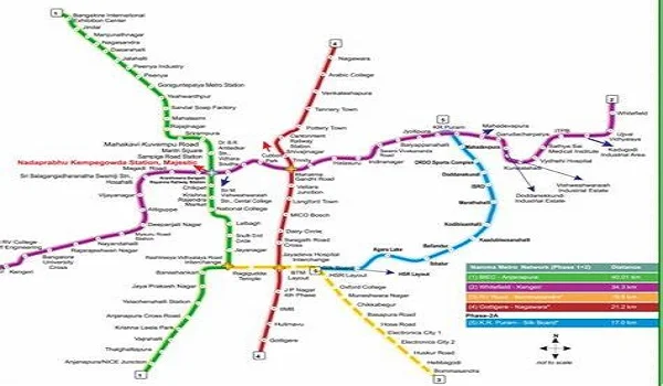
The Whitefield Metro Route Map indicates that the Purple Line extends from Whitefield in the east to Challaghatta in the west. It is more than 43 km long with 37 stations. If you live in congested areas such as Prestige Evergreen, this metro line saves you an hour every day. Rather than being stuck in traffic for hours, you can now travel to central Bangalore within an hour.
Whitefield Metro Line
Whitefield lies on the Purple Line of Namma Metro. The line traverses residences, workplaces, and shopping districts of the city. It's the busiest metro line in Bangalore presently.
- Its origin is at Whitefield (Kadugodi).
- Its destination is Challaghatta on the western edge.
- The route spans around 43 km.
- It runs through hubs such as Indiranagar, MG Road, and Vijayanagar.
For residents around Prestige Evergreen or people who work in IT parks, this is the quickest way to travel.
Whitefield to Majestic Metro Route Map
One of the most sought-after routes is the Whitefield to Majestic Metro Route Map. Majestic is Bangalore's largest metro station and connects the Purple and Green Lines.
- The journey takes approximately 1 hour.
- There are roughly 26 stations along the route.
- Key stations are KR Puram, Indiranagar, MG Road, and Cubbon Park.
- You can transfer to the Green Line from Majestic and go to places such as Yeshwanthpur or Banashankari.
This implies that the residents of Whitefield can now travel to nearly every corner of Bangalore without relying on cabs or buses.
Number of Stations on the Purple Line
The Purple Line has become one of the longest metro segments in the nation. A mere glance at the metro route map indicates how thoroughly it covers the city.
- Total stations: 37.
- East side stations: Whitefield (Kadugodi), Kadugodi Tree Park, Hopefarm, ITPL, Nallurhalli.
- Central stations: Indiranagar, Trinity, MG Road, Vidhana Soudha.
- West side stations: Vijayanagar, Attiguppe, Kengeri, Challaghatta.
So regardless of where you stay or work, the Purple Line has got you covered.
Why the Route Map is Important
A clear metro route map assists day-to-day commuters in planning better. Whitefield used to take hours of traffic, but now the travel is hassle-free and swift.
- Saves over an hour every day for office-goers.
- Increases value in residential projects such as Prestige Evergreen.
- Saves fuel expenses and stress.
- Maintains clean air by decreasing usage of vehicles.
For a new traveler in Bangalore, the map ensures it is easy and safe to explore the city.
Conclusion
The Whitefield Metro Route Map brings into focus how much connectivity has improved in Bangalore. Now with 37 stations on the Purple Line, citizens get quicker travel and improved connectivity to all areas of the city. The Whitefield to Majestic Metro Route Map is particularly convenient, connecting East Bangalore with the city center directly. For residents of Prestige Evergreen and neighboring houses, the metro has made Whitefield one of the most accessible and convenient areas to reside in.
Prestige Evergreen Blog
| Enquiry |
